Kootenai River Complex fires update Sept. 19

BOUNDARY COUNTY —- The Kootenai River Complex fires are estimated to have reached 20,908. Estimated size has not changed due to no infrared detection flight taking place.
Over the weekend the Type 2 Eastern Area Incident Management Team Gold took over managing the fires from the Northern Rockies Team 4. The fires are at 79% completion with 263 personnel. Currently there are no evacuations in place.
Active fires can mean National Forest trail and road closures on National Forests, incident management team officials wrote in a press release. Closures near the Westside Road are intended to keep people safe from active fire and responding suppression equipment, but they also keep visitors from areas where the risk of falling hazard trees is extreme.
One can still access the Selkirk Mountains north or south of the fire, such as Smith Creek or Roman Nose Mountain. Swing by the Bonners Ferry Ranger Station to pick up a map or chat with Forest staff to discuss options. Fire season is still upon us and it’s important to comply with these closures for your safety and the safety of our firefighters.
Smoke on the landscape was prominent due to an inversion layer. This also led to low intensity fire, mostly smoldering and creeping with minimal growth. The majority of the vegetative removal and chipping work continue along the Westside Road; crews are wrapping up in the north and moving south near Trout Creek Road. Crews continue to strengthen dozer and handlines and test structure protection equipment near adjacent homes. Mop up, patrol and monitoring are ongoing.
Minimal fire activity was observed over the Katka Fire by a patrol helicopter. No additional heat was reported from a few recent lightning strikes in the area.
Fire behavior is expected to be slightly more active today than Sunday. Firefighters will continue chipping the vegetation that was thinned along the Westside Road near Trout Creek Road, moving south. From Ball Creek Road north to Trout Creek Road, crews will be mopping up and strengthening firelines, removing hazard trees and monitoring fire activity. Crews will continue to routinely test structure protection equipment and conduct nighttime patrol along the Westside Road. The Katka Fire, as well as the recent lightning strikes, will be monitored by air patrol.
The weather today will be mostly sunny and slightly drier. Temperatures in the valley will be 74-78 degrees with minimum relative humidity of 27-32%. Winds expected to be light from the southwest at 2-5 mph.
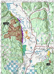
Due to active fires and fire suppression activities, the Westside Road is restricted to residents-only. Additionally, the following National Forest Trails and Roads are now closed: Ball Creek Road (FR 432), Trout Creek Road (FR 634), Russell Mountain (No. 12), Russell Ridge (No. 92), Ball and Pyramid Lakes (No. 43), Pyramid Pass (No. 13), Pyramid Peak (No. 7), Fisher Peak (No. 27), Trout Lake (No. 41), McGinty Ridge (No. 143), Clifty Mountain and Clifty/Burrow (No. 182), Myrtle Peak Trail (No. 286), and Burton Peak Trail (No. 9).
There are no evacuations currently in place. Those living on the Westside Road closest to Ball Creek, Burton Creek, and Clark Creek are in ‘READY” fire pre-evacuation status. Residents of Boundary County, Idaho can visit https://www.nixle.com or text their home zip code to 888777 to sign up for emergency alerts. To learn more about READY SET GO, visit https://bit.ly/3wi0jMu .
There are Temporary Flight Restrictions in place for air space over the Katka Fire (2-7802) and the Russell Mountain Fire (2-1621) for aviation safety. Remember that temporary flight restrictions also apply to unmanned aircraft systems (UAS) or drones.