Kootenai River Complex Fire update Sept. 20

BONNERS FERRY —- The Kootenai River Complex fires are estimated to be 20,908 acres and is at 79% completion after another day of slow fire movement.
The Type 2 Eastern Area Incident Management Team Gold has taken over as the command team for the fires.
Firefighters control a fire's spread or ‘put it out’ by removing one of the three ingredients fire needs to burn: heat, oxygen, or fuel, incident team officials wrote in a press release. They remove heat by applying dirt, water or fire retardant on the ground using hand tools, pumps on engines and from aircraft. A wildfire is deemed ‘out’ when firefighters examine the burned area for any potential of the embers or smoldering materials to escape control lines.
Fire officials witnessed mostly smoldering and creeping behavior as the fire was backing down areas in steep terrain. A helicopter made several water drops over a recent lightning strike near Long Canyon; the fire is estimated at .10 acre in size. The majority of the vegetative removal and chipping work along the Westside Road has been completed north of Ball Creek Road. Crews continued to strengthen dozer and handlines and test structure protection equipment near adjacent homes.
Minimal fire activity was observed over the Katka Fire by a patrol helicopter. Night operations were on patrol and reported a slight increase in fire behavior due to gusty winds. No infrared detection flight occurred; therefore, reported acres have not changed.
Expect to see some interior smoke from heavier timber and possible tree torching with breezy conditions on exposed ridges. Firefighters will be finishing vegetative brush removal and chipping operations south of Ball Creek Road today. Crews will continue mopping up, strengthening firelines, removing hazard trees and monitoring fire activity. Crews will be testing structure protection equipment and conducting nighttime patrol along the Westside Road.
The Katka Fire and Long Canyon will be monitored by air patrol. Fire officials are having discussions with the Forest on long-term strategic planning for suppression repair and public access.
The weather today will be mostly sunny and dry. Temperatures in the valley will be 66-71 degrees with minimum relative humidity of 27-33%. Winds expected variable out of the northeast at 4-9 mph.
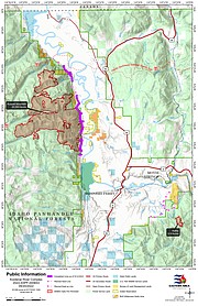
Due to active fires and fire suppression activities, the Westside Road is restricted to residents-only. Additionally, the following National Forest Trails and Roads are now closed: Ball Creek Road (FR 432), Trout Creek Road (FR 634), Russell Mountain (No. 12), Russell Ridge (No. 92), Ball and Pyramid Lakes (No. 43), Pyramid Pass (No. 13), Pyramid Peak (No. 7), Fisher Peak (No. 27), Trout Lake (No. 41), McGinty Ridge (No. 143), Clifty Mountain and Clifty/Burrow (No. 182), Myrtle Peak Trail (No. 286), and Burton Peak Trail (No. 9).
There are still no Evacuations currently in place. Those living on the Westside Road closest to Ball Creek, Burton Creek, and Clark Creek are in READY fire pre-evacuation status. Residents of Boundary County, Idaho can visit https://www.nixle.com or text their home zip code to 888777 to sign up for emergency alerts. To learn more about READY SET GO, visit https://bit.ly/3wi0jMu .
There are still Temporary Flight Restrictions In place for air space over the Katka Fire (2-7802) and the Russell Mountain Fire (2-1621) for aviation safety. Remember that temporary flight restrictions also apply to unmanned aircraft systems (UAS) or drones.