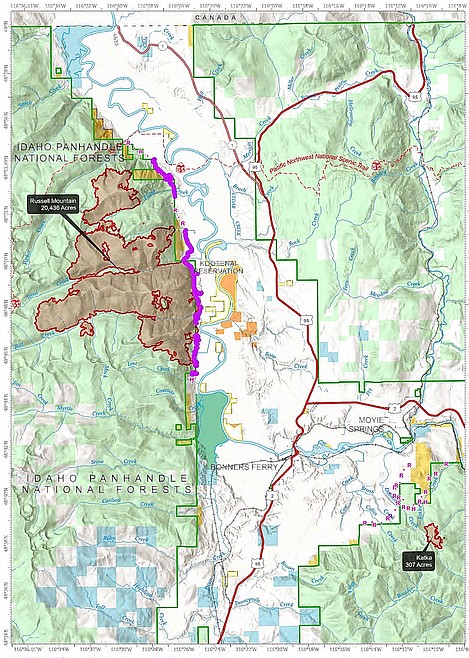
Kootenai River Complex Fire Update Sept. 15
BOUNDARY COUNTY —- The Kootenai River Complex Fire is estimated to have reached 20,744 acres as of this morning.
The fires are still at 79% completion with 366 personnel. As of this morning there are still no evacuation currently in place.
Yesterday, thunderstorms moved over the fire area bringing both lightning and varying amounts of rain from .45 inch on the south side and .10 to .20 inch on the north side.
Incident team officials said this moisture has kept fire activity minimal but has not put the fire out. Due to wet and slippery road conditions, crews waited until the rain passed before directly engaging on the fireline at midday. Firefighters began exsitiguising or removing burning material near control lines to reduce hazards south of Trout Creek Road and north of Ball Creek Road. This is also known as “mop up”.
Fire activity on the Katka Fire was observed as minimal. The overnight infrared detection flight did not get full coverage of the fire due to scattered cloud cover. The total increase in the size of the Complex was calculated to be 2 acres.
Officials said higher humidity levels will likely keep fire activity minimal for most of today. Vegetation thinning work to make the line more defensible will continue along the Westside Road north of Trout Creek Road. Crews will be mopping up along the fireline south of Trout Creek Road and constructing a hand fireline near Ball Creek Road.
A fair amount of lightning was seen over the Myrtle Creek drainage so that area will be checked for any new fire starts, officials said. The Katka Fire will be monitored and potential fireline locations scouted. Helicopters will be available for air monitoring over both fires and used for water delivery as needed if the smoke and weather conditions allow for safe flying.
Weather today will be mostly sunny with some haze. Temperatures in the valley will be 70-77 degrees with minimum Relative Humidity levels of 35-50%. Winds will be light from the southwest at 3-6 mph.
Due to active fires and fire suppression activities, the Westside Road is restricted to residents-only. Additionally, the following National Forest Trails are now closed: Ball Creek Road (FR 432), Trout Creek Road (FR 634), Russell Mountain (No. 12), Russell Ridge (No. 92), Ball and Pyramid Lakes (No. 43), Pyramid Pass (No. 13), Pyramid Peak (No. 7), Fisher Peak (No. 27), Trout Lake (No. 41), McGinty Ridge (No. 143), Clifty Mountain and Clifty/Burrow (No. 182), Myrtle Peak Trail (No. 286), and Burton Peak Trail (No. 9).
There are no evacuations currently in place. However, those living on the Westside Road closest to Ball Creek, Burton Creek, and Clark Creek have been placed in the SET fire evacuation status. SET is the stage of readiness before an actual evacuation takes place. Residents of Boundary County, Idaho can visit https://www.nixle.com or text their home zip code to 888777 to sign up for emergency alerts. To learn more about READY SET GO, visit https://bit.ly/3wi0jMu .
Temporary Flight Restrictions (TFR): There is a new TFR in place for air space over the Katka Fire (2-7802) and an existing TFR in place over the Russell Mountain Fire (2-1621) for aviation safety. Remember that temporary flight restrictions also apply to unmanned aircraft systems (UAS) or drones.

